


MapTiler Mobile
คำอธิบายของMapTiler Mobile
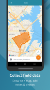
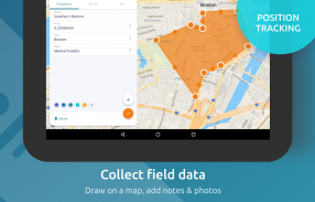
See your GPS position on your own maps. Draw points, polygons and lines on the maps. Collect field data and notes related to a location, attach a photo and fill custom properties.
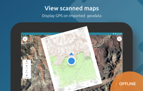
Display offline maps generated with MapTiler (https://www.maptiler.com).
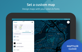
Choose from various basemaps like street and satellite. Preview on a mobile device the map you previously designed with own colors and fonts in MapTiler Cloud.
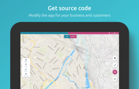
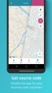
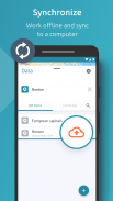
The app supports GeoJSON and MBTiles formats and data synchronization between multiple devices and desktop computer using cloud. I it easy to share the data with other people and collaborate! Perfect for mobile data collection for GIS and surveys.
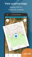
Import scanned hiking maps, PDF maps, drone aerial imagery, nautical charts for sailing and navigation with a boat or a yacht, fishing maps, aeronautical charts for flight planning by pilots, parcels and city plans and other opendata from local government. OpenStreetMap vector maps are powered by OpenMapTiles project (the successor of OSM2VectorTiles). Maps can come from existing tile servers with OGC WMTS, TileJSON or XYZ tiles from.
Supported geodata formats by MapTiler: GeoTIFF, TIFF, JPEG, ECW, SID / MrSID, NOAA KAP / BSB, DEM, OziExplorer OZI OZF2 & OZFX3, WebP, JP2, JPEG2000, GeoJP2, Erdas, Grass, Safe, Sentinel2, SRTM, NASA imagery, USGS map sheets, exports from ESRI ArcGIS, ArcSDE, etc.
The GeoJSON can be converted from / to: ESRI ShapeFile (SHP), DXF, DWG, GPX, CSV and KML.
ดูตำแหน่ง GPS ของคุณบนแผนที่ของคุณเอง วาดจุดรูปหลายเหลี่ยมและเส้นบนแผนที่ รวบรวมข้อมูลภาคสนามและบันทึกย่อที่เกี่ยวข้องกับสถานที่แนบรูปถ่ายและเติมคุณสมบัติที่กำหนดเอง
แสดงแผนที่ออฟไลน์ที่สร้างด้วย MapTiler (https://www.maptiler.com)
เลือกจากแผนที่ฐานต่าง ๆ เช่นถนนและดาวเทียม ดูตัวอย่างบนอุปกรณ์มือถือแผนที่ที่คุณออกแบบด้วยสีและแบบอักษรของตัวเองใน MapTiler Cloud
แอพรองรับรูปแบบ GeoJSON และ MBTiles และการซิงโครไนซ์ข้อมูลระหว่างอุปกรณ์หลายเครื่องและคอมพิวเตอร์เดสก์ท็อปโดยใช้คลาวด์ ฉันแบ่งปันข้อมูลกับผู้อื่นได้ง่ายและร่วมมือกัน! สมบูรณ์แบบสำหรับการรวบรวมข้อมูลมือถือสำหรับ GIS และการสำรวจ
นำเข้าแผนที่การปีนเขาที่สแกนแผนที่ PDF จมูกภาพถ่ายทางอากาศแผนภูมิเดินเรือสำหรับการเดินเรือและการนำทางด้วยเรือหรือเรือยอชท์แผนที่ตกปลาแผนภูมิการบินเพื่อการวางแผนการบินโดยนักบินพัสดุภัณฑ์และผังเมืองและรัฐบาลท้องถิ่นอื่น ๆ แผนที่เวกเตอร์ OpenStreetMap ใช้พลังงานจากโครงการ OpenMapTiles (ผู้สืบทอดของ OSM2VectorTiles) แผนที่สามารถมาจากไทล์เซิร์ฟเวอร์ที่มีอยู่ด้วย OGC WMTS, TileJSON หรือไทล์ XYZ จาก
รูปแบบข้อมูลภูมิศาสตร์ที่รองรับโดย MapTiler: GeoTIFF, TIFF, JPEG, ECW, SID / MrSID, NOAA KAP / BSB, DEM, OziExplorer OZI OZF2 และ OZFX3, WebP, JP2, JPEG2000, GeoJP2, Erdas, หญ้า, ปลอดภัย, SentinelTM2 ภาพถ่ายแผ่นแผนที่ USGS การส่งออกจาก ESRI ArcGIS, ArcSDE เป็นต้น
GeoJSON สามารถแปลงจาก / เป็น: ESRI ShapeFile (SHP), DXF, DWG, GPX, CSV และ KML
MapTiler Mobile--เวอร์ชั่น2.0.1
(12-03-2020)MapTiler Mobile - ข้อมูล APK
เวอร์ชั่น APK: 2.0.1แพ็คเกจ: com.maptiler.geoeditorเวอร์ชั่นล่าสุดของMapTiler Mobile
เวอร์ชั่นอื่น


แอปในประเภทเดียวกัน


คุณอาจจะชอบ...


